HISTORY

In the 1790's, David Urquhart of Braelangwell estate, erected the mill as a flax mill to scutch locally grown flax and a mill to card and spin wool. The mill was in operation in January 1797 under a manger brought in by Urquhart along with others "who had a knowledge of sorting, scribbling, carding and spinning". Gordon's Mill was typical of small scale spinning and carding mills of the time.

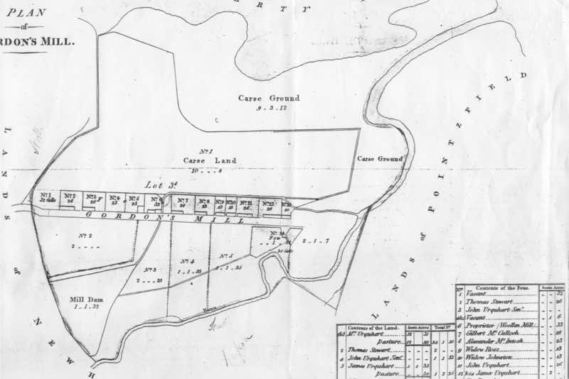
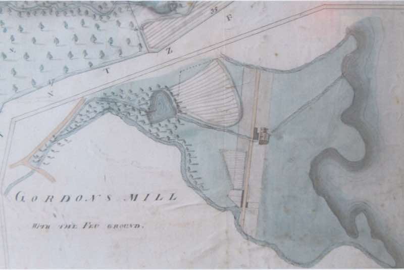
A number of feus were laid out parallel with the mill track with the intention being to statrt a small village. Ironically the present 4 buildings follow this process although the feus to the south east are largely gone, with only the vestiges of one, the ruins of a house where a polytunnel now sits, being evident. Another picture - following - shows the Gordon's Mill feus and indeed the names of the inhibitants when the map was made.

After Urquharts death in 1811, marketing and promotion appears to have lapsed, leading to the mill venture and village failing. Together with Urquharts death, the national trade crisis of 18814 and 1816/17, larger scale ventures and markets to the south with additional cotton based fabrics becoming more popular, all ultimately led to the mill becoming uncompetitive.
MILL

  • This is a fascinating archive. The mill is beautifully drawn and coloured and really quite detailed. Also of interest is the tail race / lade is given as tracking across the present field to seawards and not, as it does today, running to the south at approximately 120 degrees anticlockwise into Newhall Burn. Also the Camilty Burn doesn't appear to contribute to the mill dam. No "Whisky Park" or "Shawfield" buildings are shown to the west either.
  • This map now shows the mill lade running parallel with the lots to the north of the right most feus. It shows the mill and kiln as conjoined as now and the lead from the mill dam. It also shows what would have been the road or path from Jemimaville to Invergordon (Inverbreakie as it was then) which passes in front of the mill.
  • This sheet shows the mill, the cottage and other buildings in the feus to the south east. The mill is shown as a corn and barley mill at this point and the lade, not backfilled at this stage, is also shown.
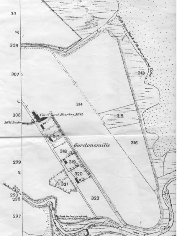
  • This Ordanance Survey sheet shows the mill as a corn mill with, alongside, a saw mill. The cottage is also shown to the south. There is a picture of the cottage and a wedding party taken during the Great War. This picture is in this gallery.
  • Adjoining cottage destroyed by fire in 1950's. This photograph (by Donald Fraser) shows a wedding party outside the cottage which, regrettably, is now a ruin, with only the east wall partially remaining.
  • The field opposite (to north west of mill) is still used for growing crops. This picture shows a steam powered threshing mill in operation opposite shawfield cottage. The tree in the distance is still there and is opposite the entrance track to the mill and the other houses. Date not known.

The name Gordon's Mill has variously been written as above, or Gordons Mills or Gordonsmill at various times and in various documents. Thus the mill is called Gordon's Mill, by us. That's also the name given by the Ordnance Survey presently. The first house on the track down from the B 9163 is called Gordon's Mill House. The remaining ones are Cygnus House, then Third House and finally Gordons Mill. The two, more recently built houses were completed and marketed in 2001.

LOCAL

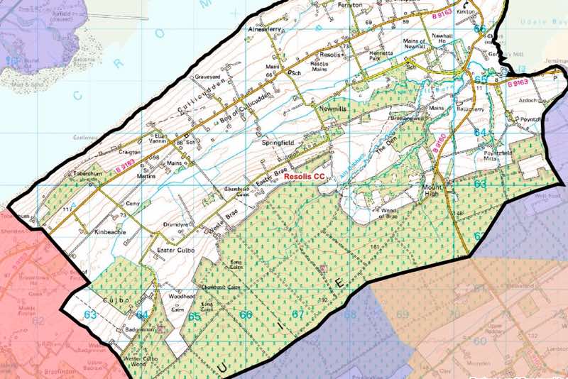
  • This map is from the Highland Council website and represents the area of the Black Isle Ward that Resolis CC covers.
  • Signage on main roads into Resolis erected by Resolis CC. This one is on the descent before Mount High.
  • Not just any "way" but Kingsley Wood Way. This road was named after a visit by the then Chancellor of the Exchequer in August 1943 to the forestry plantations of the Black Isle. Wiki info : https://en.wikipedia.org/wiki/Kingsley_Wood. More local forestry info can be found here: https://cdn.forestresearch.gov.uk/1952/04/fcfh059.pdf.
  • These ruins still indicate the scale of this tower house even although the west wall has almost totally collapsed. This edifice, build by Thomas Urquhart of Culbo, on lands granted by the Bishop of Ross, was started in the early 16th century. It would have commanded a fine sighting of the inner Cromarty Firth and certainly was in a strategic position to monitor the various crossing of the firth from Alcaig up to Alness and perhaps beyond.
  • Built circa 1805 by Donald Mackenzie of Newhall. It comprises of a two storey and basement rectangular building, with a projecting portico with pediment and paired Doric columns. The Mains have been sensitively restored to function as a restaurant and suites of self contained bedroom and living areas. The large enclosed courtyard now sports a croquet lawn. Entry is via a pend in the south front surmounted by a doocot tower. A small grass airstrip is laid out to the west of the Mains.
  • A sensitively restored kirk now housing a collection of memorial stones of some note. St Michaels is now in the care of the Kirkmichael Trust and was re-roofed and the walls securely refixed after it became even more precarious during a storm resullting in a complete restoration in 2016-18. The kirk had become disused after the formation of Resolis parish church in 1662. The chancel became the burial place for the Urquharts of Braelangwell and the nave the mausoleum to the Munros of Poyntzfield. The grave yard also houses a burial enclosure dated circa 1680 by William Grant of Ardoch for the remains of his wife Florence Dunbar.
  • Jemimavile is a small road side village on the north side of the road and was laid out about 1825 and named after Jemima Graham, wife of Sir George Gun Munro of Poyntzfield. In the centre is the rather fine Free Church Manse of 1845 of single storey with two bow windows either side of the main door. Udale Bay name harks back to Norse times and is a large mud / sandy bay much favoured by wild fowl on passge in the winter months. Remains of a fish trap can be seen at low tide - GR above refers to its location.
  • A picture of one of the many (up to 20 at one point) mobile operated drilling units which have been moored in the Cromarty Firth during periods of low demand or whilst transitting to be moved along side Invergordon for remedial work.
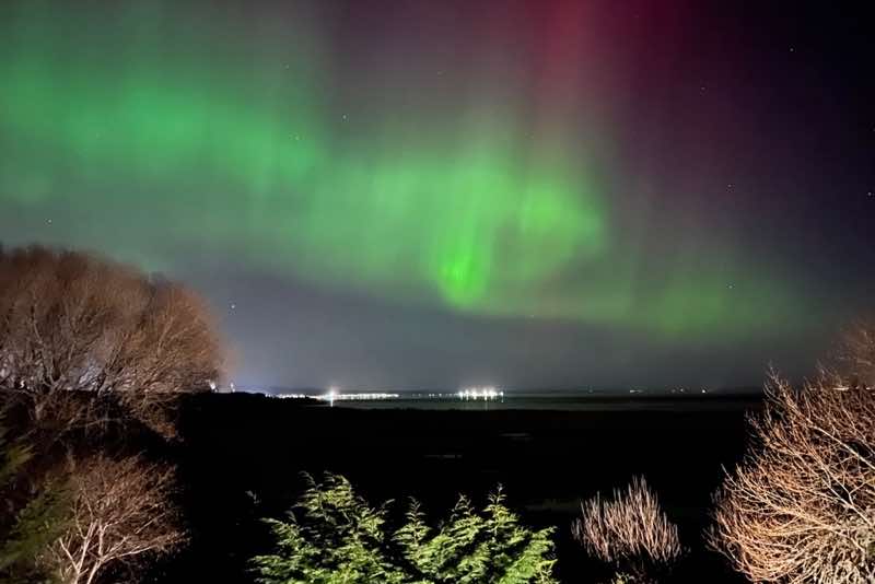
  • Another view from the mill looking out towards Saltburn on the other side of the Cromarty Firth. The aurora can be quite spectacular if the artifical lighting from shore bases and vessels is not too over powering.
  • Gifford called it a "rustically smart small harled, mansion". It was built by Sir George Gun Munro in 1757 and named in honour of his wife; Charlotte Poyntz. Comprises of a 'U' shaped plan 3 storey house, with a distinctive tower ending in an ogee roofed octagon from which the views out over Udale Bay and beyond are quite special. Adjoining gardens are run as a herb nursery. A long ascending driveway via corniced ball finialled gate piers near the main road set the scene. A grey Fergie tractor sits at the bottom.
  • A wooden shed used as a post office and opened on Thursdays only, located on the other side of the road from the main village. It is next to the local service bus stop and local notice board.
  • Prior to Tescos superstore being built on this site the area was given over to the Dingall Mart. Hence this monument with a 'coo' atop the stone. The mart had been on the location since the 1880's. During the twentieth century two main markets dealing with sheep, cattle and pigs had been a flourishing trade. In time they were both bought over by neighbouring marts and in 1992 the two firms amalgamated to form Dingwall Auction Marts, Ltd. The mart moved to its new location in July 2003 and the Tescos new store opened shortly thereafter.
  • The importance of Dingwall from early times is attested by its name which is derived from the Norse Thingvollr, meaning the field of the council and the court of justice. Situated near the mouth of the River Conon and at the head of the Cromarty Firth, its appearance from the Firth with high ground to either side is reminiscent of Norwegian towns at the head of fiords. The Norse meeting place is thought to have been in the vicinity of Gallows Hill. Even earlier, the prehistoric vitrified hill fort of Knockfarrel, some three miles to the west, along with other settlements on the surrounding higher ground, all testify to the attraction of the location as a centre of population. Dingwall’s own river is the Peffery and its Gaelic name, Inbbir-Pheofharan (Inverfearan) simply means the town at the mouth of the Peffery (cf. Inverness). Dingwall was created a Royal Burgh in 1226 under a charter granted by King Alexander ll. James IV granted a charter of confirmation in 1497and this was ratified by James VI in 1587.
  • The Emigration Stone at Cromarty Links was carved by Richard Kindersley and erected on the 10th October, 2002. It bears the names of the emigrant ships which sailed from Cromarty harbour in the 1830s and 1840s, bound for the colonies. The list of ship names reads as follows: Ami; Ann; Asia; Blagdon; Boyne; Brilliant; Canada: Cleopatra; Clio; Corsair; Dalmarnock; Diligence; Economist; George; Good Intent; Headleys; Industry; Isabella Simpson; John; Jane Kay; Kate; Lady Grey; Lady MacNaughton; Lamb; Lord Brougham; Planet; Poland; Robert & Margaret; Rover; Salamis; Theodora; Triton; Tweed; Vestal; Viewforth; XYZ; Zealous; Zephyr.
  • The war memorial was unveiled in 1921, at a ceremony attended by some 300 members of the Parish. The display of crossed sword and rifle, the garland and the burning urn was a common assemblage of symbols, but gracefully and sombrely arranged on the Resolis war memorial. The memorial was unveiled by General Sir Walter Ross, KBE, CB of Cromarty, who was accompanied by Lady Ross. It is the scene of the nations remembrance services in November each year.
  • The Black Isle Ploughing competition is held annually and this photograph was taken in 2003, when it took place on several fields in the vicinity of Newhall Bridge.
  • A small, largely overgrown and infilled lochan, on the top of what was a moor before Forestry Commission planting after the cessation of WW1.
  • Single storey brick hall. Exterior is half exposed brick and half render. The year 1959 is featured above the front entrance. The "imposing front and side doors" are from Rosehaugh House. It is used for concerts and events through out the year.
  • The Nigg Yard, found in Nigg Bay off the Cromarty Firth, was built by Highland Fabricators and opened in 1972. The yard has one of the largest dry docks in Europe for the construction of North Sea oil platforms. At its height the yard employed more than 5000 people but has since been transferred to Global Energy. Currently the Port of Nigg plays an important part in the construction and storage of equipment for offshore renewable energy developments.
  • The two car ferry (mv Renfrew Lass) plies the firth between Nigg and Cromarty between June and late September at 1/2 hourly intervals. It is not fitted with a turntable so vehicles have to either reverse on, or off. It is constrained by unfavourable wind and during spring tides. The journey takes about 15 minutes.
  • These port facilities are part of the Port of Cromarty Firth as opposed to the Port of Nigg as in previous pictures. This area plays host to crusie liners (circa 120 per annum) and to vessels employed in the construction and maintenance of oil drilling rigs (MODU's) and to various renewable energy concerns. This vessel; the 'Bokalift' has storage for wind turbine columns and nacelles and a crane powerful enough to carry out their installation in the Moray Firth.
  • An aircraft carrier called the Queen Elizabeth which spent some time in the Firth being repaired during the final parts of its commissioning. There are no aircraft as they too were behind schedule. One of Gordon Browns many premiership follies.

The area of the Black Isle is covered with historic mouments and remains from the neolithic to present day. Pictish and Viking influences can be found in Rosemarkie, on the other side of the peninsula and the names such as Udale Bay and Dingwall allude to the Norse context. Castles and large estate mansions are close by and these are described in a separate gallery.

HIGHLAND

  • Knockan Crag is in the North West Highland Geopark area. The 'Highland Controversy' was resolved by Peach and Horne in 1907, after they explored the area. They demonstrated that though the Moine schists on the top of the crag appeared younger than the lower Cambrian rocks below, this was due to tectonic action. This phenomena was named the Moine Thrust.
  • These statues are of Ben Peach and John Horne who explored the area to study the geology and subsequently arrived at the "Moine Thrust" theory; whereby younger rocks are overlain by older ones by tectonic forces.
  • Clava Cairns. Bronze age (circa 5000 years BP) chamber tomb cairns. This site comprises of 3 round cairns surrounded by a ring of standing stones. These cairns, apart from the central one, have passages entering from the SW and are all roofless.
  • Not to be confused with a similarly named fort near Glen Nevis, this one is an Iron Age vitrified hiil fort behind Inverfarigaig, Loch Ness. Considered to have been built around 2800 years BP. It is said to be associated with "Deirdre of the Sorrows", a figure of Irish folklore who self exiled in Scotland due to jealousy over her beauty between the Ulster kings.
  • Hill fort discoverd by Edward Meldrum in 1976. A prehistoric fort (Iron Age) on a revetment projecting from the NE flank of Carn Bhuidhe. Comprises of a defensive wall enclosing an oval area of 38 mtrs by 18 mtrs. Coursed rubble wall, 2.7 mtrs thick by 1.5 mtrs high. A hut circle exists in the south partion of the enclosure. Two sheiling huts of a later date are built against the NW portion of the wall.
  • Based in the previous parish church of St Colman is a large and important museum of relics from the Pictish era. The area around the old kirk was extensively examined in archaeological digs in the 1990's revealing the area to be an important crafts area some 1200 years ago and no doubt linked to other Pictish centres such as that of Burghead, directly across the Moray Firth.
  • Imposing Pictish stone with carved Celtic Cross of 8th - 10th century. Presumably a corruption of St Devenic(k) - an early christian missionary in the Highlands. HER:MGH14233
  • The marriage stone on the outside wall with initials AS and HP alongside the date 1681, are those of Alexander Stewart and Helen Pape. This building is in the care of the NTS. Abertarff House is the oldest remaining residential house of Inverness and an important piece of Scottish domestic architecture situated in a historical part of old Inverness. Since renovation it has served a number of bodies as offices. Now in the care of the NTS.
  • The west tower is of about 16th century, as repairs to the balustered parapet are documented as being made in 1649. A lead covered bell spire sits inside the parapet of the tower. The main building is dated around 1770 and later additions in 1891 comprised of porches and apse [Ross & Macbeth]. Dormers and flèche [Carruthers] were made in 1899. The interior is a Georgian / Victorian mix. Unfortunately the kirk, in one of the most important sites on the Ness riverscape, is on sale and its future remains uncertain [2025].
  • Gifford describes it as a "sizable house of no great distinction". He further notes it was described as a mansion house in 1841, and part of the plain Georgian house are still evident at the NE corner. It was further added to in 1898 in designs by W.L. Carruthers with the volumes, presently the dining room area and frontage, completing the assemblage of this large Baronial style mansion.
  • Gothic edifice with a steeple. Built in 1878 - 80 and designed by John Rhind. Later single storey addition to rear dated 1899. [Willliam MacIntosh]. The authors primary school in the 1960's.
  • An aerial view of the remains of a fairly extensive wooden structure which presumably supported nets used to trap fish on a falling tide. Two separate 'v' outlines can be seen. There is also some stone work presumably to augment the wooden structures where the fish may have been killed before being brought ashore. Many of these device remains can be seen around the Highland coasts in different styles.
  • This sculpture, by Lucy Poett, was installed in 2010 in commemoration of the achievements of the livestock breeders, farmers, crofters and drovers of the Highlands and Islands. It is sited at the top of the road leading to the present day Dingwall Auction Mart on the south approach to Dingwall. Droving was an important method of moving livestock to far flung markets before the advent of railways.
  • The last remaining manual steel turntable vehicle ferry in the UK plies the route between the mainland to Caol Reithe (Kylerhea) on Skye, during the summer months. This vessel is the "m.v. Glenachullish" and formerly was employed on the route across the Ballahullish narrows before a bridge was built at the narrows at NN 052597. The m.v Glenachulish was built in 1969 at the Ailsa Shipbuilding Company at Troon and served the area until 1975. With the completion of the bridge she served as relief ferry at Corran, Kessock and Kylesku. It is now operated by the Isle of Skye Community Interest Company as a social enterprise and carries 30,000 passengers and about 12,000 vehicles during a typical busy season.
  • This hostel, maintained by the Gatliffe Trust, comprises of two separate black houses converted into a communal living area and a dormitory. This picture is of the rear of the dormitory building. It is situated on the east coast of Bhearnaraigh at Baile. The bay in the background is south of the hostels looking towards North Uist and the ferry from Bhearnaraigh to Harris runs across the Sound of Harris from the bay in front.
  • These buildings form part of a blackhouse village of nine restored cottages which now comprise of self catering accommodation, a gift shop and a café and is managed by the Gearrannan Village Ltd. One building was a hostel however it is not known whether this is still the case at time of writing.
  • A wrinkly tin building thought to have been built to serve the fishing community and is of wooden construction, with the timbers thought to be of Scandanavian origin. They may have been brought back as ballast after deliveries of fish to Sweden. It is believed that Lady Emily Scott, or one of her successors, was the benefactor, as Sir Edward Scott took over the North Harris Estate from the bankrupted Earl of Dunmore in 1868. It is 'C' listed and at time of writing threatened by demolishion due to the owner of the property considering works to bring it back to safe condition and upgrading would involve significant alterations. Google Maps indicate it is still extant as of September 2024.
  • 12th century castle built for the Lord of the Isles passing to the MacDonalds of Clanranald in 1493. Sited on a rocky tidal island in Loch Moidart. The castle has been mooted as being repaired and converted into living accommodation by its present owner, however HES is not enthusiastic about the notion and refused scheduled monument consent in 1999. The castle was an important focus for the Gaidhealtachd culture of music and word.
  • Tioram Castle from the south. This aerial view shows the plan of the ruins. The keep, against the south wall, the courtyard accessed via a low crude arch in the north wall. Many of the upper level had fireplaces. A well is located in the ground floor. The walls have evidence of putlock holes for wooden hoarding. It was begun around the 12th century with faairly extensive remodelling in the 16th century before lapsing into decay after being torched in 1715 by the then owner, a Jacobite, to prevent it being used by Hanoverian troops.
  • This stone, by architect and stonecutter Richard Kindersley, on a commission from Cromarty Arts Trust, is a massive tribute in Caithness flag from Spittal quarry, over four metres high and more than a tonne weight to the thousands of emigrants who departed from Cromarty for the New World on scores of ships during the 1830s. Many of the ships are named on the margins, and in the middle is an eloquent passage by Hugh Miller describing the leaving of one, the Cleopatra.
  • Picture shows removal of sand and silt build up prior to the installation of a length of pontoon in 2004. This harbour structure was designed by George Smeaton and built in 1785 and originally comprised of the longer jetty to the the east, and shorter one to the west and a mole built of stone. The mole; "Smeatons Mole" , was extended by the Admiralty with a reinforced concrete jetty and a bailey type bridge added to link to the mole. The mole was originally designed to shelter the harbour and not for mooring. Ports to allow tidal flows to scour sand out to the north subsequently blocked up which may lead to the silting of the harbour with sand flows from the beach to the west. The harbour is currently run by a trust. It was a RNLI station until crewing issues forced a move to Invergordon in 1968.
  • The larger of the two projections of the harbour with, in the background, the old Seaplane Control Tower, renovated by the Cromarty Boat Club in 2003 for use as a club house.
  • Cromarty Lighthouse was built in 1846 by engineer Alan Stevenson. A typical lighthouse of this area, with a short circular tower upon a semi-circular single-storey base. The square paned lantern has a domed top. The Egyptian single-storey keeper's houses are singularly unspoiled.<br/>The light was first lit in 1846, and converted to major automatic status in 1984 and is now no longer illuminated. The white tower is 13m high.
  • The canal was begun in 1803 and completed in 1822 and links the North Sea to the Irish Sea and allows passages avoiding the perilous route around the north of Scotland.<br/>There are 29 locks along the full length of the canal. At Cille Chuimein a staircase of 5 locks raise vessels from Loch Ness to the canal. This picture [Feb 2019] shows the locks drained to allow for restoration works to masonry and gates on this flight.
  • St Vincent, a Zulu type drifter was possibly one of the rarest boats at the Portsoy Wooden Boat Festival, photographed here in 2023. Built in 1910 by Stephen of Banff, ST VINCENT is a sailing drifter of timber carvel construction. She worked in Scottish waters for many years, first at Eriskay (CY 405), then at Wick, followed by Cullivoe, Shetland. In 1975, she left Shetland for Grimsby where she worked as a trawler, owned by Sidney Carlton. In 1980, ST VINCENT moved to Lowestoft, owned by Brian Tubby and continued fishing until the late 1980s. She was converted to a pleasure vessel thereafter and at some stage ended up in North Shields named NAUTILUS. She was brought north to Arbroath by James MacGregor in August 2007 for restoration back to original dipping lug sailing condition which was completed in 2010 and it is believed she is lying in Arbroath. Rebuild by Ullapool Boatbuilders for Summer Isles Enterprises, based on Tanera Mor in the Summer Isles.
  • The original Z-plan tower house was completed in 1567 by Clan Brodie and was partially burned by fire in 1645 by Lewis Gordon of Clan Gordon, the 3rd Marquis of Huntly. In 1824, architect William Burn was commissioned to convert it into a mansion house in the Scots Baronial style, but these additions were only partially completed and were later remodelled by James Wylson (c. 1845), Now currently under the management of the NTS and open to the public on a seasonal basis. It has a varied collection of daffodils in the grounds planted by Ninian Brodie, the last incumbent of that name.
  • Dunlichity Church was built in 1759 to replace an earlier structure of which some walls remain. It was repaired in 1826 and much recast. The graveyard contains many interesting monuments including the walled enclosure of the MacGillivrays, and a simple gabled watch-house at the churchyard gate to prevent predation of graves by body snatchers. It has ceased to be used as a kirk and current owners are the Strathnairn Heritage Association, as of 2024.
  • Redcastle was until relatively recently one of the oldest inhabited houses in Scotland. A castle on this site was first constructed by William the Lion in 1179 and was known as Edirdovar. The castle was held by Sir John Bysset 1230 and in 1278 by Sir Andrew de Besco. In 1455 the Black Isle was annexed to the Crown. By 1492 the castle and its lands were under the control of Kenneth Mackenzie, 7th of Kintail, and they remained in the possession of Clan Mackenzie until 1790. The present building is dated 1641 but incorporates earlier work of rubble and ashlar masonry which is typically associated with older structures. Additionally, the castle was remodelled in the 19th century by William Burn. The estate was bought by Colonel H.D. Baillie in 1838 and passed into the ownership of the family of Lord Burton of Dochfour. The castle was requisitioned by the army during World War II and was finally vacated and unfortunately part stripped in the 1950's and is decaying slowly.
  • Fine renovation was recently undertaken by the Landmark Trust of this tower originally initiated In 1542 when James V granted Murdo Mackenzie land to build upon on this strategic spot between the Rivers Conon and Orrin. The tower Murdo built was both fit for a civilised existence and defensible against other marauding clans. The tower was enlarged in the early 17th century and a fine stair turret added, but the fortunes of the Mackenzies of Fairburn suffered when they remained loyal to the Stuart line in the Jacobite rebellion of 1715. When Bonnie Prince Charlie rose again in 1745, the then Laird, Alexander Mackenzie, declined to fight for King George because ‘a Grasier or Farmer is all I pretend to.’ It can now be rented as a fabulous holiday letting.
  • Dated from 1655, this small tower is a simple square 2-storey tower, with double pitched roof. It is harled and rendered in a conspicous bright yellow. There are ashlar dressings and a low doorway to the south east with 2 irregular diminutive windows below the eaves on the east elevation. It has 2 small gun-loops in north gable and a datestone in the centre of the south gable and 1 further small gun-loop. There is a simple bellcote at south gable apex, and stumpy corniced stack at north all covered by a local slate roof with a stone ridge. Inside is a vaulted ground floor chamber (cell) with simple stone stairs leading to 1st floor room with chimney piece in north gable with monogram MGB and flanked by gun-loops.
  • Meaning the ‘loch of trouble’ in Gaelic, Lochindorb is a ruined 13th-century stronghold of enclosure with round corner towers, occupying all the island. There are traces of a hall block, chapel and other buildings within the courtyard. This was a property of the Comyns. The castle was occupied by the English during the Wars of Independence, and Edward I of England visited in 1303. It was held again for the English in 1335 when Andrew Moray the Regent besieged it unsuccessfully, and had to withdraw before a large army led by Edward III.<br/>The castle was then used as a prison. At the end of the 14th century, it was a property of Alexander Stewart, the Wolf of Badenoch. Lochindorb and then passed to the Douglas Earls of Moray, who strengthened it against James II, but it was dismantled after their fall in 1455, and not reused. The castle is mentioned in the process of forfeiture against the Black Douglases, including Archibald ‘pretended Earl of Moray’. The iron yett is reused at Cawdor Castle. Substantial remains survived at the end of the 18th century. The property passed to the Stewart Earls of Moray, then was sold to the Campbells of Cawdor in 1606, who sold it to the Ogilvie Earl of Seafield in 1750.<br/>During investigation of the castle and island five granite balls were found, which had probably been cast here by a trebuchet during a siege.
  • Duffus Castle was built by a Flemish man named Freskin, who came to Scotland in the first half of the 1100s. After an uprising by the ‘men of Moray’ against David I in 1130, the king sent Freskin north as a representative of royal authority. He was given the estate of Duffus, and here he built an earthwork-and-timber castle. Freskin’s son William adopted the title of ‘de Moravia’ – of Moray. By 1200, the family had become the most influential noble family in northern Scotland, giving rise to the earls of Sutherland and Clan Murray. It was originally surrounded by Spynie Loch which was subsequently drained.
  • Spynie Palace was for 500 years the seat of the bishops of Moray. During that time, the palace stood on the edge of Spynie Loch, a sea loch with safe anchorage for fishing boats and merchant vessels. A thriving settlement developed nearby. Today, nothing remains of either sea loch or medieval settlement. But the impressive ruin of Spynie Palace is the largest surviving medieval bishop’s house in Scotland.
  • Duff House was intended as the chief seat of William Duff, Lord Braco (later 1st Earl Fife). The astute businessman and politician wanted not only to succeed, but also to be seen to succeed. Architect William Adam rose to the challenge by designing an ambitious baroque mansion. Work began in 1735, with elaborate carved details mostly produced in Adam’s own stoneworks in Queensferry. Work stopped in 1741, long before the interior was finished. Copies of Adam’s original plans for the house hang in the study. These show the grand curved east and west wings that were never built. A bitter five-year court case found in favour of Adam. But he died before he could recoup the debt owed to him. Lord Braco felt so let down by the result that he never slept a night in the house. It was left to his heirs to complete the work. The grounds around Duff House were laid out in the late 1700s and early 1800s with carriage drives, walks and ornamental buildings.
  • A Royal Burgh, Fyvie was the Thanage of Formartine and the castle was established by William the Lion in the late 12th century. The castle, originally a rectangluar block enclosure, had a palace portion added in the 15th Century. It is however the Scottish Renaissance frontage to the south that is the most celebrated and imitated. This was constructed in the very late 1590's by Alexander Seton, godson of Mary Queen of Scots. This picture is of the Meldrum Tower.
  • An example of the original Scottish Baronial architecture, the seven-storey castle was completed in 1626 by the Aberdonian merchant William Forbes, ancestor of the Forbes baronets of Craigievar and brother of the Bishop of Aberdeen, Patrick Forbes of Corse Castle. Forbes purchased the partially completed structure from the impoverished Mortimer family in the year 1610. He arranged for the continued construction, completing it in 1625 or 1626, subsequently the tower fell into decay. Sir John Forbes had considered demolishing the tower and consulted the Aberdeen city architect John Smith, who advised against that course of action, stating the tower was: "one of the finest specimens in the Country of the age and style in which it was built." He decided to restore the building. Roof repairs were undertaken circa 1826; a timber base covered with slates was used. It is now under the management of the NTS.
  • This photograph shows part of the original keep with a 1840's tower addition. This edifice has been a series of accretions from the 13th century to the modern day. Notable architects and designers involved include James McLeran, Richard westmacott, Charles Barry, William Leslie and James Lorimer. It is now, from the outside, a somewhat Disney-esque affair.
  • Built from the 1550's onwards after the Bishop of Caithness granted the lands of Mey to George Sinclair, Earl of Caithness. The 16th century tower house is a Z plan embellished by William Burns with crenallated pararpets [circa 1819] and Georgian windows from about 1790. A coat of arms above the door, carved by Hew Lorimer, is installed above the front door indicating ownership by the gin swilling grand mother of the king of england, who had bought it in 1952. In 1954 the Burns west wing was enlarged by a two storey embattlemented version.
  • One of the areas many Telford bridges, Invermoriston Bridge was initially started in 1805, but it took eight years to complete, the delay caused by 'idle workers' and a 'languid and inattentive contractor'. It consists of two stone arches, straddling the two channels either side of a large rock 'island' in the middle of the channel. River flows these days are much less than when this crossing was build due to upstream hydro power dams. The present bridge was built in 1934.
  • The most recent iteration of bridges crossing the Kyle of Sutherland, Designed by Crouch and Hogg, it is a bow stringed arch structure and was completed in 1973.
  • A Telford design of causeway and dam across the mouth of Loch Fleet built between 1813 - 16. The embankment is almost a kilometre long and the original bridge is now bypassed but close by are two arches provided by Joseph Mitchell in 1837 which contain valve gates. A cute wee cottage orné nestles at the end of the bridge.
  • A fabulous twin tower house ruin in a dramatic situation built as a stronghold for the Sinclairs, Earls of Caithness from the 15th century up until the 17th century. Standing on a rocky promentary it has oversight of the North Sea bay and has a goe sheltered by the keeps to the east of Girnigoe Castle whereby supplies could be brought in by sea.
  • A Royal Navy Port Fuel Depot the tank farm comprises of a large number of brick, concrete and steel fuel tanks [41] for the Royal Navy, constructed in several phases between pre-1913 and the 1960s. The tank farm was fed by huge subterranean tanks hewn into the hill behind Inchindown, about 6 kms to the NNW. The Invergordon tanks are presently being removed and the area being remediated. One tank, ironically No. 13, was ruptured by a WW2 German bomber although the weapon deployed actually passed through an adjacent tank first before causing a large loss of containment of heavy fuel oil which entered the sea via the railway line adjacent.
  • The Nigg Oil Terminal was commissioned in 1981 by the British National Oil Corporation as part of the Beatrice development before being passed to BP to continue operations. Nigg Oil Terminal (NOT) was fed crude oil and increasing amounts of connate water laterly, from the Beatrice oil platforms by a 16" pipeline and eventually ceased total production in 2016 due to well productivity decline having supplied NOT for some 35 years before the field ceased production. NOT also handled the Ithaca Jacky production fluids for 5 years until it to was shut in in 2014. Decommissioning and remediation work at the NOT is expected to complete in 2025, at which point the site is to be handed back to the current leaseholder: the Global Energy Group.
  • The Burghead transmitting station is a broadcasting facility near Burghead for long wave and medium wave radio transmission that started service on 12 October 1936. The site is presently owned by Arqiva and houses a long wave radio transmitter on 198 kHz broadcasting BBC Radio 4 and two medium wave radio transmitters, broadcasting BBC Radio 5 Live on 693 kHz and BBC Radio Scotland on 810 kHz. The long wave transmitter is part of a network transmitting on the same frequency, the other transmitters being Droitwich and Westerglen.<br/>The station has three masts, the northern of the two large masts is 153.6 metres (504 ft), the southern large mast is 154.2 metres (506 ft) tall, while the third one is significantly lower. One of the large masts is used for the medium wave transmissions and the other is used for the long wave transmitter. The third and smallest mast is the backup antenna.
  • Foyers hydro scheme consists of one pumped hydro power station and one hydro power station and one major dam and it uses a technique called ‘pumped storage’. Water held in Loch Mhor is fed by a pipeline [pictured] to drive two 150 megawatt reversible pump-turbines to generate electricity at times of high demand, and uses cheaper ‘off peak’ electricity to pump water from Loch Ness back up to Loch Mhor ready to be reused when demand is high. It was intended that Foyers would make use of surplus electricity generated by Hunterston B nuclear power station in North Ayrshire, once the latter began operating in 1976.

The Black Isle was an important area in early Scottish medeval history as it served as a buffer from the warring factions in the north and the early dominions of the Scottish Kings from about the 11th century onwards.

The gallery also touches on poi's in the "greater" Highlands; including Aberdeenshire, and the western coast and Isles